June 13, 2017

Omaha Educator Workshop, May 21-22, 2017

By: Leif Nordstrom, Missouri River Relief


Missouri River Relief (MRR) was in Omaha, Nebraska to host an Educator Workshop. This event brought teachers from around the Midwest, including formal and informal educators. There were eight lucky participants, each one as excited as the next to be learning more about the Big Muddy and ways to spread that knowledge to others. The two-day workshop focused on both connecting participants to the Missouri River as well as detailing ways to integrate this knowledge into their classrooms. 
Ready, Set, Omaha!


Day One:

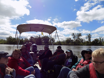
For the weekend, our MRR crew camped with the turkeys and deer at Lake Manawa State Park, outside of Council Bluffs, Iowa, settled just across the Missouri River from Nebraska-Iowa state line. The first day began bright and early Sunday. We traveled to The Narrows State Park, in Council Bluffs, to launch our boat, and then motored down-river for three lovely muddy miles to the Lewis and Clark boat landing on the Nebraska side of the river. The marina is situated just East of downtown Omaha, and the cityscape provided a scenic backdrop for the day.

Teachers gather around as Kristen begins introductions

After setting up registration at the marina, participants began to arrive. Once everyone had signed in, Kristen, MRR education coordinator, organized us into a circle for introductions. The crew, including Kristen, Jeff Barrow (MRR executive director), and myself (Leif, MRR summer intern), provided the participants with a brief background of ourselves, followed by the educators talking a little about themselves and their reason for coming. Although the individual reasons varied, they all shared an eagerness to learn. After the introduction, we got everyone fitted for life jackets, and set off down-stream, with Jeff manning the wheel. Along the way, we made observations about the river, using “I notice, I wonder, It reminds me of…” which included some unexpected observations, such as the howl of a gorilla (a teacher later cleared this up, explaining that the Omaha Zoo was situated along the river). 

Kristen uses pictures to describe the Missouri River watershed

Next, we talked about the Missouri River watershed, and the social, economic, and environmental factors that influence it. Captain Jeff also provided some background on boat navigation, describing the various signs along the riverbanks that are used by motorists to identify depth and current direction.  We talked about the history of the river and how it has changed over time, both naturally and artificially. Specific focus was given to dams and channels, where Kristen described both the benefits and detriments of each. 

Participants let the breeze flow over them as they take in the scenery 

We had lunch at the Narrows State Park, then motored downstream, eventually finding a chute to settle in to. While we floated along, Kristen prompted us to guess what the bottom of the river might look like. After we took off our sea legs and made it on land, we talked about the Pallid Sturgeon and participated in activities which related important information about the endangered fish. Once we returned to the boat, Kristen explained the various planning and management strategies for chutes, and how they are intended to assist the Pallid Sturgeon and other at-risk wildlife. Finally, we motored back to the marina, where we briefly reflected on our first day on the Big Muddy before departing. 

Day Two:

Back to the classroom for the educators on our second day of the workshop. This time, we spent the day at Fontanelle Forest Nature Center, a nature center in Omaha. 

Entrance to Fontanelle Forest Nature Center

Day two was spent off the river, and focused on student learning and understanding, as well as ways to integrate this information into the classroom. To begin, Kristen provided a template for what a Missouri River lesson plan might look like, igniting creativity throughout the educators for their own lesson plan construction to come. 

Creative minds fill the classroom on the second day of the workshop- educators, unite!

Then, we discussed the ways in which people learn, as well as how to promote discussion and encourage students. To illustrate this, we engaged in a group activity where we used a script to act out different teaching scenarios. Each of the three scripts described a different type of instructor, with techniques ranging from teacher-centered to nature-centered, with tons of fun in-between. 

Masters of their craft, educators participate in the activity using a cookie for fake scat!

After lunch, participants began working on lesson plans of their own. Educators were asked to bring copies of one of their own lesson plans, either to edit or to add new content. Participants used the knowledge gained from day one of the workshop to craft a unique lesson plan of their own! Topics included trash reduction strategies, animal adaptations, and tree identification.

Lesson plan close-up
Next, participants used giant post-it note paper as a canvas for their lesson plans, which they then placed on the wall around the room. Individually, educators went around the room in a 'gallery walk activity', observing their colleagues work, and providing comments for praise and potential improvement by placing a post-it note on the lesson plan. 

Educators provide constructive feedback to one another

To conclude our day, we gathered outside to discuss what we learned. As a whole, participants appeared to hold a deeper connection to the river when we ended than when we began. Some claimed that they would seek ways to incorporate more place-based learning into their classroom, while others reveled in the sheer complexity of the river and its many accompanying ecosystems. One permeating theme: the combination of joy and excitement that comes from being on the river. Using the Big Muddy as a vessel, we explored the complexities of student learning and understanding, while developing foundational knowledge of the river itself and its many influencing factors.

The group gathers for one last time before departure

If you would like to learn more about MRR educator workshops, please contact Education Coordinator Kristen Schulte at kristen@riverrelief.org, and check out our educator workshop page for registration information, financial aid opportunities, and upcoming events. See you on the river!

August 26, 2016

2016 Missouri River Academy

By: Melanie Cheney & Kristen Schulte, Missouri River Relief 

Imagine exploring the Missouri River by boat, learning about ecology, history and the biology of aquatic river life from experts in the field.  That is exactly what 15 high school students did during the Missouri River Academy!


 The Missouri River Academy was a five-day camp located at Camp Trinity in New Haven, MO, and supported by the U.S. EnvironmentalProtection Agency-Region 7. The Academy was developed and implemented by Missouri River Relief, a non-profit organization dedicated to connecting people to the Missouri River through hands-on, on-the-river clean-ups and education events, in partnership with the Missouri Environmental Education Association.

During the Academy students were able to engage their innate sense of wonder and natural curiosity to explore the Missouri River, while increasing their knowledge and understanding of the longest river in North America! By deepening their connection and sense of responsibility for the river, these young people will become the next generation of river stewards.


Day One – We spent time getting to know each other through introductions and team builders. The students even began their Missouri River Action Projects, by choosing an issue to explore. In the days to come they focused on mapping the impact of their issue, creating issue-related goals and objectives that they could achieve in their community and develop a plan for getting community members involved. 

We wrapped up the evening with campfire songs, stories and s'mores! And it could not have been any better!


Day Two - Was all about connecting to the Missouri River in a deeper sense using observation skills. We talked about things we noticed and wondered about while drifting down the big river. Artist Elizabeth Parris led a water-coloring activity next to the Katy Trail.

After lunch we headed up the hill to gain a historical perspective of the river from author and historian David Menke. We got to ride on a tractor and take in the views of native prairies and woodlands high above the river. We could imagine what life might have been like for all the cultures that have lived on and used the river over time. It was a great first full day, with a refreshing dip in Camp Trinity’s pool.

In the evening students continued to work on their Missouri River Action Projects and even had the chance to meet up with the local astronomy club to learn about the night sky. For a lot of these students it was their first time seeing so many stars and for all of us, it was our first time seeing the rings of Saturn.


Day Three - The day started off at 94% humidity and a whopper of a rain storm! So we did what we always do, and powered through it as best we could. 

The great folks from the Missouri River Bird Observatory set up some mist nets to give us a personal view of songbirds here in the woodlands at Camp Trinity. Sadly, because of the weather, all we caught was a cardinal! But we still learned a ton about the diversity of birds in this area. 

Then it was off to the river. Mike Smith, an educator from Washington, MO, joined us for a wetland and forestry discussion. 


Today's focus was all about understanding the interconnected communities that make up the Missouri River. After a hike through the bottom lands, we did a mini-river clean-up. Six bags of trash and two tires later, and we were back to the boats! We now have a deeper understanding of how humans impact this river, in both positive and negative ways. 


After lunch, we were joined by commercial fisherman, Cliff and Kathy Rost, along with MDC Big River Specialist Joe McMullen, who took us out fishing with gill nets! We got up close and personal with several different Missouri River fish, and even netted a few turtles! 


To wrap it all up, the Rosts brought us a special snack, caviar! Lucky for us, it turned out to be just another great day on the Missouri River.


Day Four – Was our last full day of the 2016 Missouri River Academy! Today was all about our human connection to the Missouri River. We began our morning with a phone conference with Janet Moreland, solo expedition paddler who was paddling the entire length of the Mississippi, and, in 2013, was the first woman and American to descend the Missouri River from source to sea! 

We spent some more time with historian David Menke in downtown New Haven, imagining what it was like when the steam boats arrived, taking a deeper look at the history of this town, how the area developed over time and the complexities and interactions of economic, environmental and social systems on the river. We also got to hear some really cool stories about New Haven legend and Mountain Man John Colter. 

Then it was over to Avant Garden CSA and the Riverfront Cultural Society! Carissa Cole gave us an idea of what it was like to farm this area and run a local business, while sharing some excellent produce. 


We headed to Hermann, and toured the Hermann Sand & Gravel operation where we learned all about the giant piles of sand and rock dredged from the Missouri River, and what it's like to work on a barge with Kathryn Ann Engemann, who just happens to have a tow boat named after her! 

Lastly, we headed over to the Public Works to learn what happens to the water when we flush the toilet. From history to the economics of a river town, and the environmental variations that shape this place, we took it all in stride as we went in and out of one of the hardest rain events we'd seen this week!


Day Five– Was all about connecting others to the Missouri River. Students worked hard to wrap up the last of their Missouri River Action project, a champion was named in our “Missouri River Olympics,” a game that we played throughout the week.  

In the afternoon, we headed over to the New Haven Old School House for lunch and to prepare for our Missouri River Action Project presentations. Parents, siblings, community members, teachers and friends all arrived to learn about what issues on the Missouri River sparked these young people’s interest, and the outreach and education plans that they had developed to address a specific issue in their community. The students shined and the audience asked great questions.

At the end, one student said “we engaged with so many different ideas and activities, that everyone really enjoyed. And I met so many presenters that I want to get to know further, outside of the Academy.” 

Another student said “I enjoyed every second of the Academy and I hope that I get to come again next year”. The Missouri River Academy not only engaged their innate sense of wonder and natural curiosity to explore the Missouri River, but also their desire to want to know and understand more about the longest river in North America grew!
  • View a few of the photo highlights that we enjoyed during the Missouri River Academy.
Last but not least, a big shout-out to all of the individuals and organizations, who helped make the Academy possible this year:

August 21, 2016

2017 Solar Eclipse along the Missouri River

The "Line of Totality" crosses the river 8 times - take your pick!

by Steve Schnarr, Missouri River Relief

One year from today will be a super-duper treat here in the middle of Missouri. We’ll experience a total solar eclipse! On August 21, 2017, the path of a total solar eclipse will pass from coast to coast in the United States, arriving mid-day through Missouri. While the greatest extent of the total eclipse will be in southern Illinois, mid-Missouri's experience will be just a few seconds shorter. 

For Missouri River lovers across the state of Missouri, we are really lucky. The “Line of Totality”, which represents the location where  the eclipse will be complete for the longest amount of time (almost 3 minutes along the totality line – with partial coverage lasting almost 3 hours), crosses the Missouri River 8 times. PLUS it crosses the Mississippi River once. 

Now if you thought to yourself…there’s no place I’d rather watch the solar eclipse than on an island on the Missouri River, then you are really in luck. The line of totality passes either through or within several miles of five different islands. During relatively low water flows, three of those islands are big sandbars, with massive views of the sky (one of them isn’t really an island anymore, although it is still called an island…more on that below). Interestingly, four of those islands are part of the Big Muddy National Fish & Wildlife Refuge. 

NASA has put together a great interactive map showing the path of totality. Check it out!

NOTE - Sure we are obsessing with this line - it's visual and it's fun. But you don't have to be on the center line of the "path of totality" to see the total eclipse. You can be 15 miles away and only miss a few seconds of it. The further away you are from the line the more of the total eclipse you miss (it is a parabolic curve). Play around with the interactive NASA map, or the Xavier Jubier map to see how different locations have different lengths of totality. 

So where are these spots on the river we can get the best experience of the eclipse? 
(I’ll add Google waypoints and additional directional and eclipse timing info here when I get time)

1. St. Joseph, MO – 

(crosses the river at Rivermile 447.3) - The line of totality runs just south of downtown St. Joseph. There is an island about 10 miles upstream of here – Worthwine Island Conservation Area (rivermile 457), but it doesn’t generally have a nice sandbar viewing area. 


2. Hill’s Island – near Waverly, Grand Pass, Malta Bend – 

(crosses the river at rivermiles 288, 279, 276.5) – On this large mitten-shaped series of bend in the river, the line of totality crosses the river three times in just 12 miles of the river. Best spot on the river for viewing? Remote Hill’s Island (rivermile 281). When the river is moderate to lower flows, you can count on a massive sandbar here. This is part of Cranberry Bend Unit of the Big Muddy Refuge. Hill’s Island is only two rivermiles north from the line of totality. 


3. Jameson Island – Arrow Rock, MO – 

(crosses the river at Rivermile 211) The line of totality crosses the mouth of Jameson Chute, which runs through Jameson Island Unit of the Big Muddy National Fish and Wildlife Refuge. From Arrow Rock, you can follow the Lewis and Clark Trail down to the river bottoms. The spot where the trail stops at a sandbar by the river is almost exactly the line of totality. Bring your bugspray for the walk through the forest, but they should calm down once you get to the river. If the river is flooding this trail will not be accessible.  If you have a boat or canoe, though, the largest (and perhaps the highest) sandbar on the Lower Missouri River is just 2 1.2 miles upstream, at about rivermile 213 (Saline County side – right bank descending).


4. Franklin Island Conservation Area – near Boonville, New Franklin – 

(crosses the river near rivermile 193) – Franklin Island isn’t an island anymore, but there is an island across the river (Boonville side) from it! Unfortunately, it’s a pretty steep banked island that doesn’t generally have a nice sandbar viewing area. Just downstream is the Overton Bottoms Unit of the Big Muddy National Fish and Wildlife Refuge, with several nice sandy beaches at lower river levels. 


5. Airplane Island (or Tadpole Island) – near Huntsdale, Lupus – 

(crosses the river at rivermile 179) – This sandbar emerges at about 13.5 feet on the Boonville gage. Just one mile downstream of Katfish Katy’s boat ramp. This is part of the Overton South Unit of the Big Muddy National Fish & Wildlife Refuge. However, the Corps of Engineers is doing a construction project on this sandbar during the winter of 2016-17, so we hope the sandbar still exists in 2017. 


6. St. Aubert’s Island – near Mokane, MO – 

(crosses the river at rivermile 123) – St. Aubert’s Island Unit of the Big Muddy National Fish & Wildlife Refuge is only an island at high water, really. At low water there are some beaches, but nothing really outstanding. The line crosses the river just a couple miles downstream of the Mokane MDC Missouri River Boat Ramp. 


7. Rockwood Island - (OR Grand Island) - Mississippi River 

(crosses the Mississippi River at Rivermile 101) - The "line of totality" crosses the Mississippi River at one location, right through the beautiful sandbar at Rockwood Island, 8 miles downstream of Chester, IL. However, still within just a few miles of that line is one of the most scenic spots on this stretch of the Mississippi - the Grand Tower Rock at rivermile 80. If you pick that historic power spot, you'll only miss a few seconds of full totality. Here's the Rivergator page for more info on the Grand Tower Rock. 

This is the map for Rockwood Island.


See you on the river!!!

NOTE - these maps were generated using Xavier Jubier's interactive eclipse map using Google Maps! Check it out

We'll post more details here as we have time. 

See you on the river!!!

NOTE - these maps were generated using Xavier Jubier's interactive eclipse map using Google Maps! Check it out