Mouth of the Osage River Clean-up
July 28
July 28
text by Steve Schnarr, photos by Jen Courtney
Earlier in this blog I mentioned a very interesting piece of trash...a refrigerator that travelled this spring all the way from St. Joseph, MO, to very near the mouth of the Osage River.At our July 28 clean-up, we finally got the thing off the river!!!
Here's the story...
Last summer, Missouri River Relief engaged in a very interesting journey. We mapped trash on the Missouri River all the way from Ponca State Park, NE, to the Mississippi River - 754 miles on both banks. We called it the MegaScout. (see our MegaScout blog for more stories: http://rrmegascout.blogspot.com/)
Each river mile was given a 0-5 "trashiness" rating. Dumps, appliances, massive accumulations and large trash items were GPS-ed and photographed if possible. Large floatable objects (refrigerators, hot water heaters, 55 gallon barrels, etc.) were "tagged" - we spray-painted the river mile, date and our initials ("MRR") on the side.
This would give us the chance to know, when we pulled these things out of the river, that it was something we saw on the MegaScout AND just how far it had travelled in the interim.
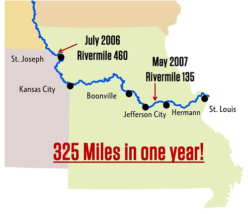
When I was scouting with Soda Popp before the Bonnots Mill clean-up, we spotted one of these refrigerators in a rack pile of driftwood. It was "tagged" with the rivermile 460, from Mill Creek Bend just above St. Joseph, MO. It had travelled 326 miles during the spring flood!!!
We knew we absolutely had to get that thing out of there at the clean-up.
It wasn't easy!
Here's a photo journal of this crazy, vagabond refrigerator:
1. Melanie Cheney "tags" it up above St. Joseph in July, 2006, at river mile 460.

2. Soda Popp takes a picture of it with his cell phone in June, 2007, at river mile 134.

3. Clean-up volunteers use a log to lift the refrigerator up so Troy Gordon can attach a come-along.

4. Using two come-alongs and a chain, Tim Nigh lifts the fridge out of the rack pile as Big Muddy Wildlife Refuge Ranger Tim Haller looks on.

5. They roll it onto the boat, then haul it to shore.
The MegaScout project was turned into an interactive GIS map of the river by our GIS Specialist Dan Belshe. The "first draft" of the project is available in two forms:
1. MegaScout 1.1 - An Arc Reader version of the map. Includes the free software necessary to read the maps, it is a "read-only" document. It doesn't include aerial photos. On a single-layer DVD.
2. MegaScout 2.0 - An ArcInfo map dataset. Includes all of the MegaScout data along with aerial photos, a shapefile of the Missouri River, dike files, public land files, streamdata, roads and more. On a double-layer DVD, it requires that the user has ArcGIS software.
If you are interested in either of these products, contact Missouri River Relief at 573.443.0292 or riverrelief@riverrelief.org.

No comments:
Post a Comment