Showing posts with label MegaScout. Show all posts

May 1, 2009

Rocheport Trash Tally!

Rocheport Bend Day of Caring
April 18, 2009
Rocheport, MO, and Overton Bottoms Unit of Big Muddy Refuge


Here's some results and a trash tally from this amazing day!

Thanks to everyone that made it happen...

Total Volunteers: 133 (73 clean-up volunteers)
MRR Crew: 32
Boats: 4 (3 Missouri River Relief; 1 Mo. Dept. of Conservation)
Stream Teams: The Mighty 211, 549, 1875, 1876, 2489, 2793
Rivermiles: 2
River level: 10.8 (Boonville gage)
Scrap Tons: 1 ton
Landfill Tons: 3 tons
Tires: 111 (est. 1.7 tons)
Total Tonnage: 5.7 tons
Bags of Garlic Mustard Pulled: 56 large bags
Trees Planted: 300 trees

Trash Tally!
More than 114 Large Stream Team Bags
111 Tires: 72 on the rim, 37 w/o rims, 1 truck tire, 2 inner tubes, 1 bicycle
4 Refrigerators
1 Chest Freezer in parts (tagged on 06 MegaScout trash survey)
1 Hot Water Heater
1 Dryer
5 Coolers
1 Bed Frames
4 Box Springs
5 Chairs
4 30-gallon Trash Cans
4 5-gallon Plastic Buckets
80 feet of 1” Poly Tubing
9 1-gallon Paint/Varnish Cans
10 feet of Garden Hose
10 feet of Plastic Piping
17 assorted Scrap Metal pieces
1 Hot Tub w/ Cover
1 Ironing Board
1 very ugly old woman rubber mask
1 Lock Pick Set
1 Lot Fence Wire
3 3-gallon Metal Buckets
1 Typewriter
3 55-gallon Metal Drums
1 Park Bench
1 Camping Table
1 Truck Bed Liner
1 Fire Extinguisher
1 Toilet
Several hundreds of pounds of roof shingles
1 Kitchen Sink
13 Mason Canning Jars

Jody Coats shows off a piece of a big freezer. photo by Scot Heidbrink

Gettin' it done in Rocheport

Rocheport Bend Day of Caring
April 18, 2009
Rocheport, MO, and Overton Bottoms Unit of Big Muddy Refuge

text by Steve Schnarr, photos by Scot Heidbrink & Melanie Cheney
check out our Rocheport Results webpage for more links & info

It all started with a commercial freezer. We came across this thing in 2006, when we were finishing off the home stretch on our MegaScout trash survey. During the previous summer and fall, we’d mapped trash on 754 miles of the Missouri, from Ponca, NE, to the Confluence north of St. Louis, MO. For thanksgiving weekend, we finished off the home stretch, from Boonville to Jeff City.

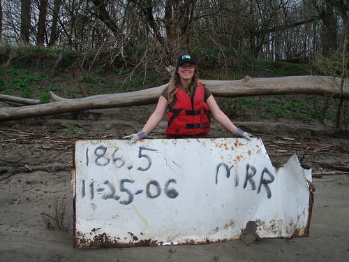
Racin’ Dave and I spotted a pile of tires and a big appliance. We GPS’d the spot (just upstream of Moniteau Creek next to Rocheport) and Racin’ spray-painted the rivermile and date on the side of the freezer lest it float away before we get it. (so far we’ve found several of these “tagged” items at clean-ups. The furthest travelled was 326 miles – click here to check out the blog post)

So when Missouri River Communities Network (MRCN) Vista member Maria Dorsey asked us if we wanted to add a clean-up component to their annual Rocheport Day of Caring on April 18, I immediately thought of that freezer. And all the trash along the Katy Trail and the tires scattered through the woods by many floods.

Soon, there was more. The Big Muddy Refuge across the river wanted volunteers to have a garlic mustard-pulling party, and that was the only weekend they could do it. So it became the Rocheport Bend Day of Caring – volunteer efforts spread on both sides of the river to improve the land.

Students from a West Junior High French Class gathered to plant 300 trees throughout city parks and along Moniteau Creek. This project was organized by Maria, then-Rocheport mayor Brett Dufur, and MRCN Americorps workers Katrina Thomas and Pam Venable. The Friends of Rocheport worked with us to put on lunch for the whole crew.

We decided to do a three-prong clean-up assault. One team worked on pulling down the remains of a collapsed building right along the Katy Trail. They bagged up the shingles and trash and left a monster burn pile ready to go. It took all morning with a chainsaw, a gas-powered chop saw, hammers, pry bars and shovels. Tires from the surrounding woods were rolled to the trail and bags of trash emerged from the surrounding forest.

Another several groups cleaned along the Katy Trail, walking deep into the forest and rolling out tires and all kinds of junk.

And some more folks hit the river, walking down the Riverwalk trail to the mouth of Moniteau Creek to meet the River Relief boat fleet. Boats took crews to the site of the aforementioned freezer, as well as a couple spots near the old head (now closed) of the Overton Chute.

The original Overton Chute had a sharp bend near its entrance, and quickly became clogged with driftwood. So the Corps of Engineers punched in a new entrance just
downstream. But driftwood and a whole lot of trash still collects in the old entrance (a spot Refuge Biologist Wedge Watkins told us about and flagged for us). Volunteers struggled through the driftwood, dragging bags full of plastic and glass and rolling refrigerators and tires to shore to be hauled away by boat.

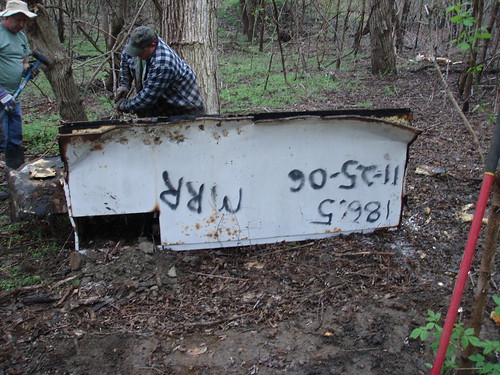
Meanwhile, volunteers Don Doughtery (who drove to the cleanup in the rain in his cool go-cart) and Alvin Sweezer broke that freezer into manageable pieces that could be hauled to shore.

Even though this was a relatively small clean-up, it was one of our most complicated, with volunteers showing up at Rocheport and then walking 1/2 mile to board boats. Boats were launched across the river at Taylor's Landing, where trash was also hauled out. Plus, the overpass to Taylor's Landing was closed, meaning an extra 10 minute drive for hauling trash and boats by land.

So activity was buzzing all over the river that day, and a whole lot got accomplished. 300 trees were planted, 56 huge bags of garlic mustard were pulled, 111 tires were removed from town and the river, and 5.7 tons of trash were hauled away.

Thanks to everyone who came out on a soggy Saturday to help beautify the Rocheport Bend!!!!

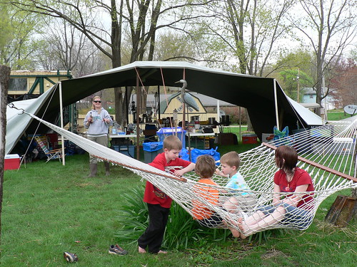
Special thanks to Brett and Tawnee Dufur, who hosted our crew camp at their beautiful Katy Trail Bed and Bikefest, and made a bunch of other things easier.

Thanks to the City of Rocheport for contributing to our lunch and disposal costs.

And thanks to the Missouri Department of Natural Resources for funding Missouri River clean-ups.
August 16, 2007

Life and Times of a Vagabond Refrigerator

Mouth of the Osage River Clean-up
July 28
text by Steve Schnarr, photos by Jen Courtney
Earlier in this blog I mentioned a very interesting piece of trash...a refrigerator that travelled this spring all the way from St. Joseph, MO, to very near the mouth of the Osage River.

At our July 28 clean-up, we finally got the thing off the river!!!

Here's the story...

Last summer, Missouri River Relief engaged in a very interesting journey. We mapped trash on the Missouri River all the way from Ponca State Park, NE, to the Mississippi River - 754 miles on both banks. We called it the MegaScout. (see our MegaScout blog for more stories: http://rrmegascout.blogspot.com/)

Each river mile was given a 0-5 "trashiness" rating. Dumps, appliances, massive accumulations and large trash items were GPS-ed and photographed if possible. Large floatable objects (refrigerators, hot water heaters, 55 gallon barrels, etc.) were "tagged" - we spray-painted the river mile, date and our initials ("MRR") on the side.

This would give us the chance to know, when we pulled these things out of the river, that it was something we saw on the MegaScout AND just how far it had travelled in the interim.

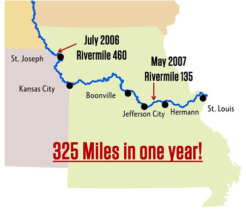
When I was scouting with Soda Popp before the Bonnots Mill clean-up, we spotted one of these refrigerators in a rack pile of driftwood. It was "tagged" with the rivermile 460, from Mill Creek Bend just above St. Joseph, MO. It had travelled 326 miles during the spring flood!!!

We knew we absolutely had to get that thing out of there at the clean-up.

It wasn't easy!

Here's a photo journal of this crazy, vagabond refrigerator:

1. Melanie Cheney "tags" it up above St. Joseph in July, 2006, at river mile 460.


2. Soda Popp takes a picture of it with his cell phone in June, 2007, at river mile 134.


3. Clean-up volunteers use a log to lift the refrigerator up so Troy Gordon can attach a come-along.


4. Using two come-alongs and a chain, Tim Nigh lifts the fridge out of the rack pile as Big Muddy Wildlife Refuge Ranger Tim Haller looks on.


5. They roll it onto the boat, then haul it to shore.


The MegaScout project was turned into an interactive GIS map of the river by our GIS Specialist Dan Belshe. The "first draft" of the project is available in two forms:
1. MegaScout 1.1 - An Arc Reader version of the map. Includes the free software necessary to read the maps, it is a "read-only" document. It doesn't include aerial photos. On a single-layer DVD.
2. MegaScout 2.0 - An ArcInfo map dataset. Includes all of the MegaScout data along with aerial photos, a shapefile of the Missouri River, dike files, public land files, streamdata, roads and more. On a double-layer DVD, it requires that the user has ArcGIS software.

If you are interested in either of these products, contact Missouri River Relief at 573.443.0292 or riverrelief@riverrelief.org.

June 15, 2007

Post-flood trash scout

Cote sans Dessein Bend - Mouth of the Osage River
by Steve Schnarr
Scouting out the mouth of the Osage

A couple weeks ago, I headed downstream to Soda Popp’s Gas Barge on the Osage River. In the mid-May “Flood of 07”, Soda’s place was hit hard. Although the water barely made it in his house, it left debris scattered all over his beautiful riverside park. He and friends had been cleaning it up for weeks, gathering it by hand and with an old mule hayrake pulled behind a tractor and burning the piles of wood and cornstalks.

By the time I got there, much of the work was done, the ground was drying out but the mosquitoes were intense. The first thing he did when I hopped out of the van was hand me a bottle of bug spray.

The water was still high on the Osage. Excess water from Truman Reservoir and the Lake of the Ozarks was still being let out to the Missouri, and the lowest part of Soda’s land was still underwater. He was obviously exhausted, but in good spirits none the less.

We hopped in our 50 horse Grizzly (the “Karp”) and checked out the scene. We found a dump we had missed last year and a good deal of “floater trash” collected in coves alongside the Osage. When we reached the mouth, we hopped out to look at the point between the two big rivers.

The flood had scoured the underbrush clean along the point, leaving deposits of sand and mud everywhere. And plastic trash dotted the landscape on the Osage side. But not nearly what I expected in that spot.

We jumped in the boat and headed around the dike structure that keeps the Osage tight against the towering bluffs on the downstream side. Upstream, on the Missouri now, we cruised through a small chute on river-right. The flood had obviously collapsed the high banks of the island, but we could see no trash deposits here. But upstream a bit, where we pulled several boatloads of trash out of the woods last year, was another large deposit of trash.

Driftwood was piled high along the banks. Lining the top and cascading down the bank side was a collection of typical Missouri River trash – balls, plastic bottles, coolers, tires, a couple buoys and, as we drew closer, we noticed a refrigerator stuck in the rack pile.

“That one’s got your spray paint on it,” Soda pointed out. Sure enough…scribbled on the side of the refrigerator was a date (7/06), a rivermile (460) and our initials (MRR). On last year’s MegaScout trash survey, we had “tagged” each appliance we could get to with the rivermile and date, so we could track how far big stuff would go in high water. I admit I was a little amazed when I realized how far this thing had gone. “That’s up in northwest Missouri,” I said, shaking my head. Just above St. Joseph on the Mill Creek Bend, to be exact.

We were at about river mile 134. Soda snapped a photo with his cell phone. Here it is:


Here's Melanie last summer "tagging" the same fridge 326 miles upstream.


Soda and I were at about river mile 134 – 326 miles downstream. That refrigerator had negotiated the bends of western Missouri, where levees were popping like mad, swung east at KC and wound through the Grand Bend past the new chutes at Lisbon and Overton, through the Manitou Bluffs and past the state capital.

Right now is a fascinating time to be out on the river. The floods reshaped the banks and bottom, moved around trees and drift and repainted the landscape with human refuse. As the waters continue to drop (we hope, we hope), a new river landscape is emerging. It’s our new place of work and there’s a lot to do

You can watch the pulse of a river by watching the drift and trash. As the river and its many tributaries rise quickly, everything gets picked up and shoved downstream. At times the whole river seems so chock full of trees, plastic bottles and refrigerators that you could walk across it if it weren’t headed downstream at 7 miles and hour and constantly churning.

As pulses of drift move down, the channel where the river runs swiftest is actually higher than the slower water inside the bends and behind dike structures. The debris slides down the water slope and gathers in huge spirals in the eddies. This is why you can always find light “floater trash” on the inside bends. The river seems to sift it out. This happens every time the river goes up and down.

But in a raging flood stuff boogies downstream fast. Wing dikes don’t matter anymore and neither do river banks. This flood, at least in mid-Missouri, stayed at about the same level for five days, fed by record rains up the Grand River. A lot of stuff got moved on through and what is mainly left behind is stuck in drift and up on the banks where the flood scoured through the riverside forest.

Let us know what you’ve seen about the new trash scene on your stretch of the Missouri River. E-mail at riverrelief@riverrelief.org.