Showing posts with label 07 flood. Show all posts

August 16, 2007

Life and Times of a Vagabond Refrigerator

Mouth of the Osage River Clean-up
July 28
text by Steve Schnarr, photos by Jen Courtney
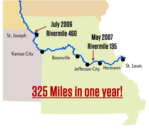
Earlier in this blog I mentioned a very interesting piece of trash...a refrigerator that travelled this spring all the way from St. Joseph, MO, to very near the mouth of the Osage River.

At our July 28 clean-up, we finally got the thing off the river!!!

Here's the story...

Last summer, Missouri River Relief engaged in a very interesting journey. We mapped trash on the Missouri River all the way from Ponca State Park, NE, to the Mississippi River - 754 miles on both banks. We called it the MegaScout. (see our MegaScout blog for more stories: http://rrmegascout.blogspot.com/)

Each river mile was given a 0-5 "trashiness" rating. Dumps, appliances, massive accumulations and large trash items were GPS-ed and photographed if possible. Large floatable objects (refrigerators, hot water heaters, 55 gallon barrels, etc.) were "tagged" - we spray-painted the river mile, date and our initials ("MRR") on the side.

This would give us the chance to know, when we pulled these things out of the river, that it was something we saw on the MegaScout AND just how far it had travelled in the interim.

When I was scouting with Soda Popp before the Bonnots Mill clean-up, we spotted one of these refrigerators in a rack pile of driftwood. It was "tagged" with the rivermile 460, from Mill Creek Bend just above St. Joseph, MO. It had travelled 326 miles during the spring flood!!!

We knew we absolutely had to get that thing out of there at the clean-up.

It wasn't easy!

Here's a photo journal of this crazy, vagabond refrigerator:

1. Melanie Cheney "tags" it up above St. Joseph in July, 2006, at river mile 460.


2. Soda Popp takes a picture of it with his cell phone in June, 2007, at river mile 134.


3. Clean-up volunteers use a log to lift the refrigerator up so Troy Gordon can attach a come-along.


4. Using two come-alongs and a chain, Tim Nigh lifts the fridge out of the rack pile as Big Muddy Wildlife Refuge Ranger Tim Haller looks on.


5. They roll it onto the boat, then haul it to shore.

The MegaScout project was turned into an interactive GIS map of the river by our GIS Specialist Dan Belshe. The "first draft" of the project is available in two forms:
1. MegaScout 1.1 - An Arc Reader version of the map. Includes the free software necessary to read the maps, it is a "read-only" document. It doesn't include aerial photos. On a single-layer DVD.
2. MegaScout 2.0 - An ArcInfo map dataset. Includes all of the MegaScout data along with aerial photos, a shapefile of the Missouri River, dike files, public land files, streamdata, roads and more. On a double-layer DVD, it requires that the user has ArcGIS software.

If you are interested in either of these products, contact Missouri River Relief at 573.443.0292 or riverrelief@riverrelief.org.

July 24, 2007

Post-flood clean-up

“Black Star”Clean-up at Alligator Cove
June 23, 2007
text by Steve Schnarr, photos by Melanie Cheney
Bouncing Back
Many of the news stories of the Flood of 07 focused on the bursting of agricultural levees in Western Missouri and Eastern Kansas. For those that live right on the Missouri River, without levees, it was one long river of heartbreak. But floods are a part of life on the river, and these tough people cry when they need to but get right back up and rebuild.

Of course no one deserves the overwhelming work and loss that a flood brings, but river folks do know that eventually it’s going to happen. It takes vision, strength and community for folks to go through it and come back to the river. But they know that they have to get back, and the only way to do it is through a lot of hard work and calling in your friends to help get it done.


When floodwaters reshape your world, it becomes an opportunity to start a new vision, to clean up and make things even better.

At Alligator Cove (Rivermile 343), John Breyfogle had built a perfect riverside haven. Beneath towering cottonwoods was a cabin on pontoons, a two-tiered deck made from an decommissioned pontoon boat overlooking the river, and a music stage built on the flatbed of an old two-ton truck.


These things all got destroyed in the flood, which filled up and coursed through the whole place. John’s house was covered in mud, and all the carpet had to be ripped out. With the help of friends and family, and countless hours of after-work effort, the place was cleaned out, mud was scraped, utilities gotten up and running, the barn reorganized, the salsa garden replanted, John’s tiller dismantled and worked back into shape.

Demolition Derby
John figured his friends in River Relief would be good for doing some of the big teardown work. He put together a work day and invited us all out. Vicki arranged for a scrap dumpster and Michael cooked up some food. Racin’ Dave and John Jansen brought cutting torches and everyone showed up with a smattering of hand tools. Folks left Columbia around six, and everyone convened at the cove. Nick Recker, Stephanie Williams and her partner Ken surprised us all and showed up with tools.

It was a long day of destruction.

As we tore the rotting stage off the back of the truck, Racin Dave busted out his tools and started dismantling the cab, gas tank first. He shook his head and said, “This is one of those things where you just take off a week and go after it.” And then, with Lindsay’s help, he proceeded to reduce the truck to an engine block, a pile of plastic and upholstery and countless chunks of steel cut into three-foot pieces for scrapping. All in one non-stop day, before dinner.


Jeff Barrow, Michael and the John B’s focused on the “floating” cabin. The beautiful little cabin on pontoons did float, but was toppled by the force of the current, smashing the building and loosening the structure. The windows and any good lumber or siding was salvaged, but everything else went to the burn pile or dumpster. Nails were pulled, and the John B’s (Brady and Breyfogle) went at the pontoons with dueling chop saws.

Here's the cabin as they started working on it...


This is what was left when they were done...


During the flood, the deck overlook collapsed when the bank underneath slid into the river. Nick, Stephanie, Ken and Melanie worked it all day, pulling nails and stacking the joists and decking up on the remaining deck. All together, we probably filled a five gallon bucket with nails pulled from salvaged lumber. John Jansen came after work with his torch, and worked on an old piece of a dredge.

Anthony, Jeanie, Janie and Steve moved from project to project, helping the teardown when needed, picking up trash between stages of the destruction, preparing food.

Dinner was fantastic, and we gathered, exhausted around the campfire at night. John thanked everyone for helping, and, laughing, passed out black star pins as a reminder of the day.

It’ll be a while before John can move back in, but he’s excited that now he has a reason to build a home up on stilts. The vision of this place has definitely not been washed away, but it’s a fresh new beginning and we are all excited to see it blossom again.

June 15, 2007

Post-flood trash scout

Cote sans Dessein Bend - Mouth of the Osage River
by Steve Schnarr
Scouting out the mouth of the Osage

A couple weeks ago, I headed downstream to Soda Popp’s Gas Barge on the Osage River. In the mid-May “Flood of 07”, Soda’s place was hit hard. Although the water barely made it in his house, it left debris scattered all over his beautiful riverside park. He and friends had been cleaning it up for weeks, gathering it by hand and with an old mule hayrake pulled behind a tractor and burning the piles of wood and cornstalks.

By the time I got there, much of the work was done, the ground was drying out but the mosquitoes were intense. The first thing he did when I hopped out of the van was hand me a bottle of bug spray.

The water was still high on the Osage. Excess water from Truman Reservoir and the Lake of the Ozarks was still being let out to the Missouri, and the lowest part of Soda’s land was still underwater. He was obviously exhausted, but in good spirits none the less.

We hopped in our 50 horse Grizzly (the “Karp”) and checked out the scene. We found a dump we had missed last year and a good deal of “floater trash” collected in coves alongside the Osage. When we reached the mouth, we hopped out to look at the point between the two big rivers.

The flood had scoured the underbrush clean along the point, leaving deposits of sand and mud everywhere. And plastic trash dotted the landscape on the Osage side. But not nearly what I expected in that spot.

We jumped in the boat and headed around the dike structure that keeps the Osage tight against the towering bluffs on the downstream side. Upstream, on the Missouri now, we cruised through a small chute on river-right. The flood had obviously collapsed the high banks of the island, but we could see no trash deposits here. But upstream a bit, where we pulled several boatloads of trash out of the woods last year, was another large deposit of trash.

Driftwood was piled high along the banks. Lining the top and cascading down the bank side was a collection of typical Missouri River trash – balls, plastic bottles, coolers, tires, a couple buoys and, as we drew closer, we noticed a refrigerator stuck in the rack pile.

“That one’s got your spray paint on it,” Soda pointed out. Sure enough…scribbled on the side of the refrigerator was a date (7/06), a rivermile (460) and our initials (MRR). On last year’s MegaScout trash survey, we had “tagged” each appliance we could get to with the rivermile and date, so we could track how far big stuff would go in high water. I admit I was a little amazed when I realized how far this thing had gone. “That’s up in northwest Missouri,” I said, shaking my head. Just above St. Joseph on the Mill Creek Bend, to be exact.

We were at about river mile 134. Soda snapped a photo with his cell phone. Here it is:


Here's Melanie last summer "tagging" the same fridge 326 miles upstream.


Soda and I were at about river mile 134 – 326 miles downstream. That refrigerator had negotiated the bends of western Missouri, where levees were popping like mad, swung east at KC and wound through the Grand Bend past the new chutes at Lisbon and Overton, through the Manitou Bluffs and past the state capital.

Right now is a fascinating time to be out on the river. The floods reshaped the banks and bottom, moved around trees and drift and repainted the landscape with human refuse. As the waters continue to drop (we hope, we hope), a new river landscape is emerging. It’s our new place of work and there’s a lot to do

You can watch the pulse of a river by watching the drift and trash. As the river and its many tributaries rise quickly, everything gets picked up and shoved downstream. At times the whole river seems so chock full of trees, plastic bottles and refrigerators that you could walk across it if it weren’t headed downstream at 7 miles and hour and constantly churning.

As pulses of drift move down, the channel where the river runs swiftest is actually higher than the slower water inside the bends and behind dike structures. The debris slides down the water slope and gathers in huge spirals in the eddies. This is why you can always find light “floater trash” on the inside bends. The river seems to sift it out. This happens every time the river goes up and down.

But in a raging flood stuff boogies downstream fast. Wing dikes don’t matter anymore and neither do river banks. This flood, at least in mid-Missouri, stayed at about the same level for five days, fed by record rains up the Grand River. A lot of stuff got moved on through and what is mainly left behind is stuck in drift and up on the banks where the flood scoured through the riverside forest.

Let us know what you’ve seen about the new trash scene on your stretch of the Missouri River. E-mail at riverrelief@riverrelief.org.


May 13, 2007

May 13 - Rolling with the flooded river

A Surprising yet relaxing spring weekend in the Heartland
by Melanie Cheney
photos by Melanie Cheney

Well, this weekend we were supposed to be helping 300 volunteers clean-up on the banks of the Missouri River near St. Charles, MO. However, that river had plans of her own, and she sent us packing for home.

After spending the first night on Pelican Island checking the boats every hour because the water was receding down the sandbar at a rate of a foot every hour, we found out she was going into major flood stage back at home in CoMo and soon to follow in St. Charles. After our Birds, Bugs and Botany field trip on Monday, we proceeded to pack up that evening and leave at dawn the following day.

It took us half the day to load up and drive back to Columbia only to unload and try to help the local communities with our baots and vans. We took off to Rocheport where they had set up a major sandbagging operation. WE had fun, although I was sick from exhaustion by the time I finally made it home.


What I really want to write about is what an amazing weekend we just had because of our beloved raging river. First of all, she didn't crest as high as expected...saving our river clubhouse (Club Medfly) and our hangout at Cooper's Landing. Secondly, I got to relax all weekend with no obligations. We were free to visit with good friends, eat good food and play in the beautiful spring outdoors.

My new love and I got to camp out underneath the cool starlit sky for two nights, sleeping in new places, walking in new woods, checking out the woodland ferns and wildflowers, stopping at the "Moon Rocks" in the creek, going for a morning swim amonst the clear trickling waterfalls.

We then went for a jaunt over to Strawberry Hill nursery, where my sweetie took me plant shopping and then home to beautify the gardens. We soaked up some sunshine while planting mint, cleomes and impatients, taking shady hammock breaks before finishing up to pack a cooler and head down to the Big Muddy once again.

Anthony (Boudreaux) met us on the flooded River Road with a canoe and guided us through the flooded bottomlands and creeks to Coop's. To our surprise, music was playing and people were hanging out, wading around in their mud boots, relaxing on docks tied up in the flooded parking lot.


Dinner had just been cooked and we enjoyed the beautiful warm sunset amongst great company. Naked Dave and Dyno were perched in the bow of Barb and Roger's houseboat (sitting on it's trailer with water all around) and they serenaded us with outrageous acoustic jams. Soon, the barred owls started their wild hooting and proceeded to make "owl love" all night long. It was amazing. By then, Anthony had rigged his canoe with a tiki torch and took us on an evening canoe ride in the backwaters. Only the sounds of owls, frogs and the occasional dip of the paddle filled the otherwise silent night.

We paddled back to our clubhouse for the night, making a bed on the back deck, right over the surging waters of the flooded river. Somehow, we managed to sleep dry and peacefully. What an amazing and ambitious adventure, yet such a relaxing and wonderful weekend.

My love and respect for the river has continued to grow, along with my great gratitude for all she gives.